Editor’s notes: This is another in an ongoing series of articles we call “Marking History” looking at the stories behind the hundreds of historic markers scattered about the Crossroads.
It was the Road to the King.
El Camino Real.
“A trail of adventure, hardships, opportunity and freedom, over which history stalked into Texas,” according to one historic marker in Robertson County.
The road stretched 2,500 miles through sometimes desolate borderlands, up from Mexico City and through Texas to Louisiana.
The viceroy in Mexico City was the representative of the Spanish king in the Americas, and any road leading to the king, or his representative, was named El Camino Real, the Road to the King.
Men like Davy Crockett, Sam Houston and James Bowie came into Texas on the King’s Highway, wrote Emily Moskal in a 2017 article for Texas Parks and Wildlife.
For millennia before Texas pioneers traversed the road, bison carved it out, faithfully migrating the long path at the southern end of the Great Plains, followed by Indigenous peoples.
The road was briefly dubbed the Old San Antonio Road but was re-christened, in 2004, El Camino Real de los Tejas. The road was designated a National Historic Trail that year.
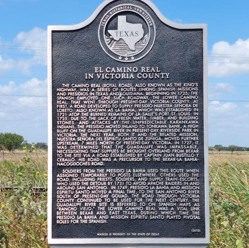
Victoria also has a marker dedicated to the historic trail, out on U.S. 87, in the vicinity of Nursery, about 3.6 miles north of Zac Lentz Parkway.
The marker is entitled “El Camino Real in Victoria County,” and it’s hard to spot. The usual brown road signs announcing the presence of a historic marker are absent. Grass has grown tall around its base, providing a natural camouflage.
The neglected marker isn’t even mentioned in the Guide to Texas Roadside Historical Markers written by Betty Dooley Awbrey and Stuart Awbrey with the Texas Historical Commission. The most recent edition was published in 2013, almost three years after the Victoria County marker went up.
Neither is Victoria County mentioned in various materials about the Royal Road available at the Victoria Regional History Center, including a survey with field notes and a detailed map of the road, compiled in 1915-16.
It’s all very confusing. The marker is in northwest Victoria County, but El Camino Real never was?
Also on hand at the history center is a thick El Camino Real research file compiled by Henry Wolff Jr. The bulk of it seemed reassuring — a large volume of information — sure to provide an answer.
At the front of the file, Wolff placed a full-page photo of the marker and scrawled underneath it one word: “Questionable.”
Wolff had lengthy correspondence with a few historians, politicians, and National Park Service officials. His communications indicate that he was opposed to the marker going up.
In fact, he seemed pretty passionately opposed, writing in one email, “As to Victoria County being on the Camino Real, camino reales or whatever it is, frankly I don’t give a damn one way or another, but it amazes me that after all the years since the Spanish colonial period, we have (local historians) trying to convince us of it. Somebody must have gotten on the wrong road back there.”
Packed into Wollf’s file were pages and pages supporting his assertion that the marker was questionable.
However, one thing he included could support the Victoria County El Camino Real marker: a copy of a few chapters from a Texas Department of Highways and Public Transportation “Tricentennial History: 1691-1991” of the King’s Highway.
“Camino Real hardly seems an appropriate description for the network of Indian trails, natural stream crossings, and exploration routes that made up northern Mexico’s communications system in the colonial period,” Jesus F. de la Teja wrote.
The Victoria County marker claims that a portion of the Lower Camino Real crossed northwest Victoria County, a detour of a sort from the main road. Perhaps, such a detour, or break from the main road, can be a part of the network routes de la Teja wrote about.
After all, it can be logically supposed a detour from the main road brought some travelers to Martin De Leon’s Spanish colony.
However, Wolff noted in his file, “A detour does not a highway make.”
The El Camino Real de los Tejas National Historic Trail definitely does not come into Victoria County. Wolff placed the trail pamphlet in his file — the road is clearly north of Victoria County.
Perhaps it is best here to defer to what Roy Grimes, the author of “300 Years in Victoria County,” wrote.
“What came to be known as El Camino Real, the King’s Highway, from the Rio Grande through San Antonio and on to the deep forests of East Texas, left the Victoria area off to the south of the main line of travel,” Grimes wrote in 1968.
Recent Comments